MAPPING
Mapping And Survey Drawings
We at Unique CADD Services offer CAD DRAFTING SERVICES and look forward to partnering with you to INCREASE EFFICIENCY & PROFITABILITY of your business in terms of preparing Survey Drawings and Mapping Requirement.
We have worked with Civil engineering’s, construction firms, real estate development companies and surveying professional.
Survey Drafting Services For Infrastructure Development
Surveying or land surveying is the technique, profession, and science of determining the terrestrial or three-dimensional position of points and the distances and angles between them. Surveying of the land has formed the basis of all civilizations which have built or farmed and continues to underpin every piece of architecture, infrastructure, rural, urban or mining development. Land surveyors ensure the integrity of property boundaries, legally defining the dimensions of new and existing land, reserves, resource protection areas, easements, and titles.
Land surveyors design and project manage sustainable urban and rural areas, for commercial and residential developments, according to local government development principles. We specialize in helping clients with offering drafting services ranging from a small layout drawing to preparing complete project including Design, Analysis, Drafting and preparing Drawings and Reports.
CAD Drafting / Survey Drawing Drafting / Mapping For Various Requirements
We offer CAD drafting for surveying companies. As a CAD outsourcing services firm, we have professional experience in producing survey CAD drawings and civil site engineering drawings for Layouts, Road, Canal, Railway projects.
We Convert Output from different Survey Instruments such as Auto Level, Total Station.
Services Offered In Relation To Surveying And Mapping
Topographic surveys – Contour Map Traverse Correction
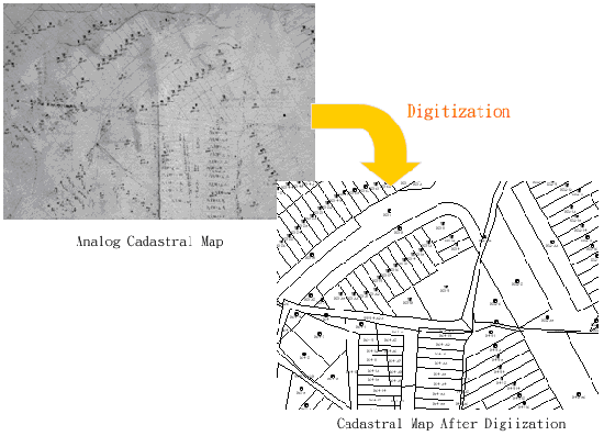
Raster to Vector Conversion - Tippan Maps / Village Maps
Profile Preparation & Earthworks Calculation – Road, Railway, Canal, Nala, Pipe Line
Layout Design
Utility mapping
Boundary surveys
As a CAD services outsourcing company, we offer reliable and economical CAD drafting services for engineering, architecture, survey projects.
Survey CAD Services Outsourcing
Surveying has been an element in the development of the human environment since the beginning of recorded history. The planning and execution of most forms of infrastructure projects require it. It is also used in transport, communications, mapping, and the definition of legal boundaries for land ownership. It is an important tool for research in many other scientific disciplines. We offer drafting services to Surveyors, Engineers, and Land Developers. Our highly trained staff is always eager to tackle the next challenge presented to them no matter how small or large the task. We also produce feature survey, contour, earthworks and as-constructed plans. Deliver high-quality survey drawings which act as a base for design drawing at very cost effective prices to clients.
Why Use Our Survey CAD Services?
We use Industry Standard Software ESurvey CAD to prepare Drawings Quickly
Having worked over more than 1000 different Survey Drawing Project, we have learnt best Practices of presenting Survey Drawings in best possible way.
We also setup CAD standards for your company, if required.
We can offer output in Desired Format such as CAD / PDF or any other Standard Format
We can assist you with your production needs at any stage of the development of your projects. By using us as consultants on a per project basis you can ensure an increase in productivity for your office, and compete for more projects without an increase in overhead.
We have worked extensively with Architects, Interior Designers, Engineers, Space Planners, Landscape Architect, General Contractors, Builders, Real Estate Brokers and Owners.